Handheld GPS units are extremely handy for remote navigation, but they can also be useful for a number of other reasons. Many units allow you to track mileage, set waypoints, and locate geocaches in your area.
The birth the term ‘geocaching’ is largely attributed to Matt Stum, who first used it on the “GPS Stash Hunt” mailing list in May of 2000 (1). Geocaching is essentially a real-world, outdoor treasure hunting game that requires the use of a handheld GPS-enabled device (2).
Our list of the 10 Best Handheld GPS units includes selections that give users access to preloaded topographic maps, detailed road networks, rural and urban land use distinctions, and much more!
1. Garmin GPSMAP 64st
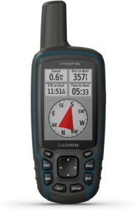
This Garmin GPS is perfect for users looking for a unit that provides accurate climbing or hiking information, as well as details on nearby trails, rivers, lakes, and other points of interest.
The GPSMAP 64st features a 2.6-inch sunlight-readable color screen and a high-sensitivity GPS and GLONASS (3) receiver that offers superior reception. It also boasts a 3-axis electronic compass with barometric altimeter and comes with a yearlong subscription to BirdsEye Satellite Imagery.
2. Magellan eXplorist 310 Summit Series
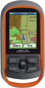
The Magellan eXplorist 310 is designed for all types of outdoor recreation activities and offers detailed topographic maps for nine U.S. regions that include accurate digital terrain information and contour lines.
The Summit Series GPS unit offers high-resolution display on a brilliant, 2.2-inch sunlight-readable color screen. The unit also features information on water features, urban and rural land use, paperless geocaching download, and 18 hours of battery life.
3. Garmin eTrex 30x
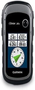
This Garmin unit is great for anyone who likes to have a variety of maps at their disposal for navigation. The unit’s 3.7GB of internal memory and microSD card slot allow you to store many map formats, including TOPO 24K, HuntView, BlueChart g2, City Navigator NT, and more.
The eTrex 30x also features an upgraded 2.2-inch, 65K color sunlight-readable display and a preloaded, worldwide base map with shaded relief. It also boasts wireless sharing of waypoints, tracks, routes, and geocaches with other compatible devices at the touch of a button.
4. Garmin Inreach Explorer+
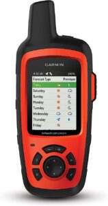
As its name suggests, the Inreach Explorer+ is a great unit for distance travelers, mountaineers, and explorers. The ability to track and share your location with family and friends is a great feature of this GPS unit.
Garmin also outfit the Explorer+ with 2-way text messaging available from anywhere through 100% global iridium satellite coverage (this feature requires satellite subscription). It features an interactive SOS feature that triggers and sends a signal to the 24/7 search and rescue monitoring center in the event of an emergency.
5. Garmin 750t
Garmin redesigned the antenna on their 750 TOPO model for improved satellite reception and enhanced the unit’s rugged design to make it perfect for avid hikers, bikers, hunters, climbers, kayakers, and more.
The Oregon 750t features multilink wireless connectivity via Wi-Fi, Bluetooth, and ANT+ (4). It also boasts Active Weather support with animated radar overlays, a built-in 3-axis compass with barometric altimeter, and a 1-year BirdsEye Satellite Imagery subscription.
6. Delorme InReach Explorer
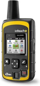
Delorme’s version of the Inreach explorer is designed for the adventurer who likes to plan ahead and share their travels with friends and family, no matter how remote they might get! With two-way communication included, this GPS unit allows you to do just that!
This unit allows for advanced planning of routes, including waypoints, and it gives you the ability to share your location so that friends and family can track your progress. Additionally, this GPS offers a digital compass, barometric altimeter, and accelerometer.
7. Garmin Montana 610
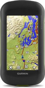
Another stellar GPS from Garmin, this unit is designed for geocaching experts that can’t let colder temperatures slow them down. With over 250,000 preloaded geocaches and a glove-friendly touchscreen display, you’ll be able to hunt for caches year-round.
The unit also features a track manager that gives you the ability to easily organize and navigate through waypoints, routes and track log. It also boasts a high-sensitivity, WAAS-enabled (5) GPS receiver that provides accurate positioning in deep canyons and heavy cover.
8. Garmin eTrex Touch 35
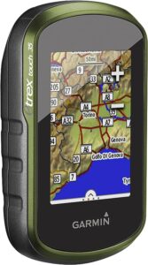
Designed with the multi-sport outdoor recreationist in mind, the eTrex Touch 35 allows you to create activity profiles to keep your favorite navigation profiles organized for hiking, climbing, fishing, hunting, geocaching, and more!
This Garmin GPS features a 2.6-inch color, capacitive touchscreen display and a tilt-compensated electronic compass that gives accurate headings even when standing still. It also boasts built-in mapping with shaded relief, a barometric altimeter, smart notifications and ANT+ connectivity.
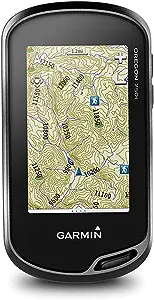
9. Garmin Oregon 650t
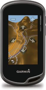
Unique among GPS units, the Oregon 650t is perfect for outdoor recreation enthusiasts that need navigation help and also want to capture the beauty of the places they navigate to. This unit has a built-in 8MP digital camera.
Garmin included a large, 3-inch sunlight-readable touchscreen display with multi-touch capability and three sensors that provide information for the unit’s 3-axis compass, accelerometer, and barometric altimeter. The unit’s dual-orientation also allows you to switch between landscape and portrait views.
10. Bad Elf 2200 GPS Pro
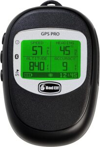
The 2200 GPS Pro is perfect if you’re looking for a GPS unit that can connect with a variety of your devices. Using Bluetooth technology, this unit can connect with up to 5 devices at a time, including iPhones, iPads, iPad minis, and iPod touches.
The 2200 GPS unit from Bad Elf features a large LCD screen with backlight to ensure easy night operation. It also offers a standalone GPS data logger that can store more than 100 hours of tracking data. This unit boasts extra-long battery life and 10Hz reporting rate, as well as a rugged and splash-proof design that meets IPX4 standards (6).
–
Buyer’s Guide
Choosing the right handheld GPS for you means thinking about how you’re going to use it, what your favorite outdoor activities are, and what features are essential to your needs. With that said, there are factors that separate good GPS units from great ones.
In this buyer’s guide, we will focus on three important characteristics: location accuracy, connectivity, and battery life.
Location Accuracy
A GPS that doesn’t provide accurate headings and location information is ultimately an ineffective GPS. The location accuracy of any GPS unit can vary depending on a number of factors, including satellite geometry, signal blockage, atmospheric conditions, and the design of the actual unit.
Many GPS units won’t update location information and headings unless it’s in motion. In other words, standing and simply turning in circles with your GPS can sometimes lead to inaccurate information. For reference, GPS-enabled smartphones are typically accurate to within 16 feet (7).
Unfortunately, there are no GPS units that can guarantee an exactly perfect location every time. There are simply too many variables out of the unit and user’s control. In general, however, the most accurate handheld GPS units are those that also incorporate differential GPS programs, such as WAAS or GLONASS.
Connectivity
The ability to communicate from a remote location is an important feature for many users. Whether it’s simply to check in with friends and family while hiking the Pacific Crest Trail or sending an emergency message in a time of desperation, a connection to the outside world is a very nice aspect of most GPS units.
Just like in the early days of text messaging, most units equipped with two-way communication will limit you to around 160 characters. Two-way communication is typically provided through access to global satellites (much like satellite phones), but some require a subscription to satellite coverage.
There are a variety of GPS units that claim to offer one-way communication. The main problem with this, however, is that there’s no way to tell if a message has been received. When selecting a GPS unit, consider the importance of sharing your location and communicating with a search and rescue monitoring center should anything go wrong.
Battery Life
Let’s face it: a GPS unit with a dead battery is simply taking up space in your pack. It’s good for nothing if you can’t turn it on. That’s why a best practice for handheld GPS units is to only power them on when you absolutely need to use their functions. Don’t leave them on in your pack throughout the day!
The battery life of GPS units can vary from less than 10 hours to more than 100 hours. Some are compatible with solar panels for the purpose of recharging and some can function on both rechargeable batteries and disposable alkaline batteries.
In general, you want to choose a handheld GPS that has at least 10 hours of battery life so that you can use it for most of the daylight hours without needing to change batteries or recharge.
Frequently Asked Questions
The Navy built the first real satellite navigation system, which it called TRANSIT, in 1959 (8). GPS units have become much more advanced since then, but it’s as important as ever for consumers to have as much information as possible before making a selection. So let’s look at a few of the most common questions about handheld GPS.
What is the difference between a ‘route’, a ‘track’, and a ‘waypoint’?
A ‘route’ is used for navigation and consists of a series of straight-line waypoints that you will navigate in a sequential order specified by the user.
A ‘track’ is a record of where you’ve been and more accurately reflect the twisting and turning shape of most trails.
A ‘waypoint’ is a location that can be stored in a GPS receiver in the form of coordinates, allowing you to easily select navigation to that point. Each waypoint is assigned a unique name or number.
How does my GPS know where I am?
GPS units receive signals from GPS satellites. These satellites transmit several signals to provide orbital information for the satellites in the system. Most GPS receivers store several days of data, which speeds up location acquisition.
What are the main causes of poor GPS reception?
Some causes of poor GPS reception include environmental interference and the number of visible satellites relative to your position. The features/design of individual GPS units also has an impact on GPS reception.
What if my GPS can’t lock onto any satellite signals?
Some receivers have difficulty finding signals indoors. If your unit can’t lock onto a signal, take it outside and set in under an open sky, ideally stationary, for about 30 minutes. Once your unit acquires a signal, don’t turn it off immediately, as it needs time to download satellite almanac data.
How important is buying a GPS with an electronic compass?
The primary function of an electronic compass is to show the direction you should travel. Most new models with tri-axial compasses will provide accurate headings even when you don’t hold them level.
How can I find geocaches in my area?
Geocaching is a fun, treasure-hunt-style activity for groups or individuals. It’s also a great way to learn how to use your handheld GPS. To get started you can visit the Official Geocaching website (9) and enter your zip code. Prepare to be surprised by how many caches are nearby.
Are there ‘best practices’ for geocaching?
The number one rule when you find a geocache is that you can’t remove an item from the cache unless you replace it with another item of equal or greater value. You should also be sure to sign the logbook and make sure you hide the cache just like you found it once you’re done. Also, be sure to log the cache in your GPS once you return home.
Will my new GPS prevent me from ever getting lost?
No. You can still get lost with a GPS, although the idea of them is to significantly decrease the odds. Some ways you can still get lost with your GPS include forgetting spare batteries, failing to bring a map and compass as a backup, and overestimating the effectiveness of a GPS unit in a dense forest or deep canyon.
Summary
Magellan Navigation Incorporated is largely credited with being the creator of the world’s first commercial handheld GPS receiver, which debuted in 1989 (10). Since then, GPS units have rapidly improved in accuracy, battery life, connectivity, and more. We wish you the best of luck in finding your own handheld GPS!